The
modern Muir trail follows the south fork of the Kings River to its headwaters below Mather Pass, crosses the pass, and descends the Golden Staircase, the last-built part of the modern trail. Prior to the construction of the Staircase in 1938, the trail went down the south fork from Pinchot Pass, then north over Cartridge Pass, down Cartridge Creek, then to rejoin the modern route along the middle fork of the Kings. Just north of Cartridge Pass is beautiful Lake Basin, now missed by the Muir trail. This trip took us to the basin via the remnants of the old trail, which receives just enough use to serve as a useful route into the basin. See the end of this post for trail notes.
Our party was the same as in 2006: Jonathan, friend Chris, and Bob. Our itinerary:
Day 0: Drive to Taboose Creek and camp in 98-degree heat and wind. Not as bad as it sounds.
Day 1: Hike up about 4500 vertical feet and 6 miles of trail along Taboose Creek
Day 2: Over Taboose Pass, 11,400 feet, down to the south fork of the Kings, south on the modern Muir trail for half a mile, then continue along the south fork to camp at an unnamed lake halfway up to Cartridge Pass, at 11,000 feet.
Day 3: Over the pass, 11,700 feet, camp in early afternoon at the lake in Lake Basin closest to the pass, then explore the basin without packs for the afternoon.
Day 4: Back over Cartridge Pass and Taboose Pass, camp just over the pass.
Day 5: At the car at noon and drive home in time for real food.

Ready to go
 Taboose Canyon

Upper Taboose Canyon

Taboose Pass, 11,400 feet
 Looking west from Taboose Pass, into the Canyon of the South Fork of the Kings River

Dusk at our second camp, at the lake halfway up Cartridge Pass

Lake Basin

Looking south from the approach to Cartridge Pass
 From our camp at the lake halfway up Cartridge Pass

Just above the lake

Chris
 Jonathan with map during our route-finding puzzle

Looking north from Cartridge Pass into Lake Basin
 Looking down the chute from the pass

Chef Jonathan in Lake Basin
 Nightfall in Lake Basin
 Dawn
Dawn


Looking up the chute at Cartridge Pass on our return

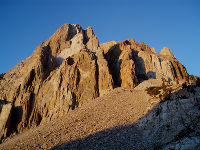
 Arrow Peak

Dawn on the day out
Trail notes:
The standard source for off-trail info is R.J. Secor's The High Sierra: Peaks, Passes, and Trails (Google "Secor Sierra"), but the old Muir trail is too easy to merit any useful information in that book. The location of the old trail is correctly marked on the 7.5 minute quad, Mt. Pinchot. Do not even think of taking this route without that map!
Northbound:
It's easy to find where the old trail leaves the new Muir trail, just north of the point where the new trail crosses the south fork after descending from the junction with the Bench Lake trail. The Park Service has put up a couple of barriers to prevent JMT hikers from descending the south fork. The old trail is easy to follow down to the point where the first of three big boulder fields comes down to touch the river. At this point, the old trail crossed the river to avoid the boulders, but that part of the old trail is impassable because of a major blowdown of the trees on that side. You must stay on the north side of the river.
The best route seems to be to stay as close as possible to the river on its north bank. You can pass the first boulder field on a trail, but you will need to cross boulders for the second and third. In between, faint use trails come and go.
There is a marker in the forest where the trail turns north to ascend Cartridge Pass. If you can't find the marker, follow the route on the topo and you will eventually find the switchbacked trail, which is well marked up to the halfway lake.
The next trick is to find the trail north of the lake. We lost a lot of time in careless route-finding here. Again, follow the route on the topo with care and a compass and you will find another well-marked trail. We never use GPS but it would have saved us a lot of time. The trail will take you over the pass and down a steep chute to Lake Basin, where route-finding is easy.
Southbound:
Make your way to the highest lake in Lake Basin, below the pass. The chute carrying the trail is obvious. After ascending and descending the pass, go to the far end of the halfway lake and search for the trail down to the bottom, using the route on the topo. Stay close to the north bank of the river when you reach the bottom. Search for the trail at the bottom of the east-most boulder field and proceed to the new Muir trail.


 Allerton Gardens, part of the National Tropical Botanic Gardens


