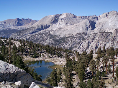
This trip took us into the area just north of Mt. Whitney, in the V formed by the Sierra crest and the Kings-Kern divide, south of the latter. Those who have hiked the length of the Muir trail know the divide as the second-highest point on the trail (just over 13,000 feet) and the highest pass, Forester.
We entered by Shepherd Pass, known as one of the harder ways to get over the crest from the east side, but the only direct way into this area. You could cross the crest easily a bit to the north over Kearsarge pass, but that brings you in north of Forester. You could come in through Whiteney Portal to the south, but that's a hard permit to get and a strenuous hike in the company of thousands of day hikers. Finally, you can start in Cedar Grove, go over Avalanche Pass, down the northside of the divide, and back up the south side. Bob did this in 1992. The return to Cedar Grove could be over Forester Pass or the cross-country route over Harrison Pass (but watch out for terrible bushwacking on the lower part of the descent).
The itinerary:
Camp 0: Car camping on the road from Independence to Kearsarge Pass (Onion Valley). A nice spot. Watched The Big Lebowski before retiring.
Camp 1: 7 miles in and 4,000 vertical feet at Anvil Camp, still on the east side.
Camp 2. Just south of Lake South America, in an exposed and sun-beaten area. We wished for more clouds!
Camp 3. Near the intersection of the Kings crossover trail and the trail down to Junction Meadow. On this day we put our packs down for an hour and walked up to Lake South America, a high alpine gem, then down to camp at mid-day, and spent the afternoon in lovely Milestone Basin, a place that would be crammed with people if it were not so hard to reach. Highly recommended. Although not shown on any map, there is quite a good trail most of the way into the basin. We did find the source of the Kern, right next to our camp--see picture below. The Kern becomes one of the main feeders of the mighty Sacramento River.
Camp 4. We hiked back over Shepherd Pass, early enough to start thinking of the virtues of real beds. We decided better and looked to camp again at Anvil Camp, but it was filled with a huge packer party. So we pushed on. It finally got so dark and we so tired that we slept by the trail. Next morning we found that we were much closer to the car than we realized, drove down to Independence, and had McD breakfast. Lunch at In n Out in Manteca and home in late afternoon.


 We ran out of water on the trail (many of the creeks marked on the topo as year-round turned out to be dry). So we made a difficult descent to Shepherd creek and drank gratefully. The scramble back up was horrible.


And here it is! The Mighty Kern River at Camp 3.